(Phnom Penh): Hotspot snapshots are frequently used in news media and social media, leading to incorrect conclusions and heightened public fear.
Understanding the Basics: What are Snapshots and Hotspots?
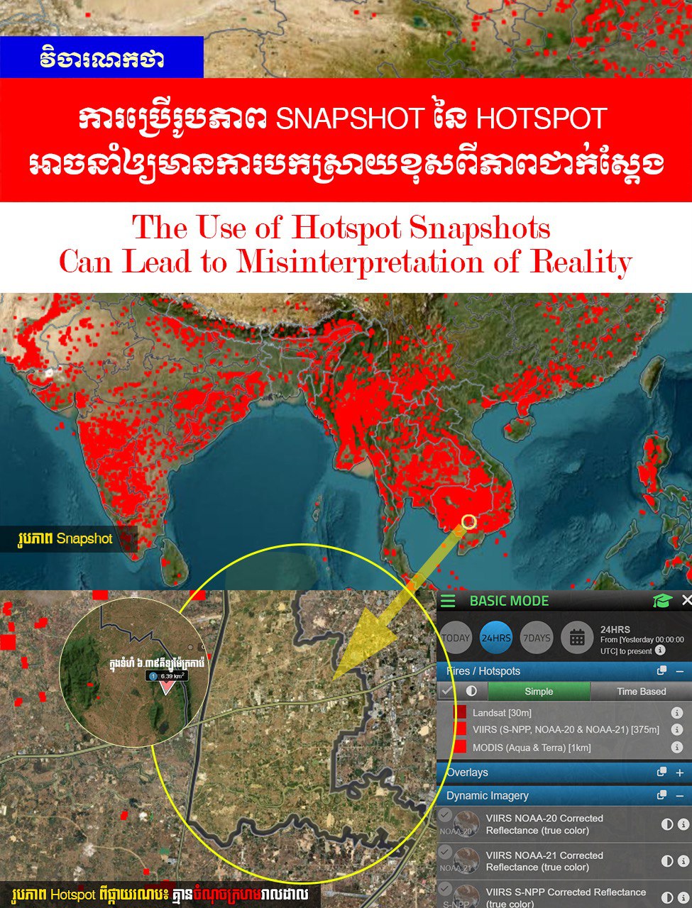
Snapshot
In photography, a "snapshot" refers to a quick, candid photo. However, in the context of satellite data or hotspots, a snapshot is a screen capture or an image showing a state at a very specific, brief moment. It is like "freezing" an action occurring at that exact second into a single image.
Characteristics of Snapshots in Hotspot Data:
- Lack of Metadata: A snapshot is just a flat image file (like a JPG or PNG). It does not contain the digital metadata that allows us to click for precise coordinates or measure specific heat levels.
- Low Resolution: When we take a snapshot or screenshot from a phone or computer, the resolution is limited to that screen's quality. It is not the high-quality Raw Data from the satellite.
- Visual Distortion: Snapshots often display heat points as large "pixels," which makes the burned area appear much larger than it actually is.
Hotspot
In environmental and satellite contexts, a Hotspot refers to a "location with an unusually high temperature" compared to its surroundings.
How do Hotspots occur? Satellites orbiting the Earth are equipped with Sensors that can detect Infrared radiation (heat). When these sensors detect intense heat from the ground, they designate that point as a "Hotspot."
Sources of Hotspots (What are they?): Not every hotspot is a forest fire. They can be:
- Waste burning: Burning trash or plastic in open fields.
- Agriculture: Burning rice stubble or clearing land for farming.
- Forest fires: Caused by nature or human activity.
- Factories/Industry: High-heat chimneys can appear as hotspots.
- Intense ground heat: Occasionally, sun-scorched rocks or dry soil can cause a "False Positive" on a satellite.
A hotspot is merely a "thermal signal," not a 100% accurate measurement of fire size without further technical analysis.
1. The Science Behind Hotspots: The Illusion of Scale
Technically, satellite sensors capture heat in the form of Pixels.
- Resolution Issues: Snapshots often have low resolution. When multiple small heat points are close together, they "merge" into a single, large bright red area. This is known as Spatial Averaging—a technical phenomenon where small heat points appear larger than they are. This creates a perceived "Extensive Spread" when, in reality, it may just be isolated, small points.
- Color Saturation: Using intense red in snapshots can lead viewers to overestimate the severity of a situation, but it does not represent the actual "intensity" or specific heat level.
2. Snapshot: Loss of Context and Critical Data
A snapshot is a static view that hides important truths:
- Undefined Boundaries: Without a proper Scale, a viewer cannot tell if the burning area is 10 meters or 10 kilometers wide.
- Misinterpretation of Heat Levels: In some cases, a snapshot may actually show a lower heat level than reality if the color scale is not calibrated to the actual field temperature.
3. Social Impact and Perception
When hotspot snapshots are shared in the media or on social networks without proper technical context, they increase public fear, spread misinformation, and lead to wrong conclusions. A snapshot is valuable only for "visualization"—it is not definitive "scientific evidence."
To understand the real situation, we need High-Resolution Data and expert interpretation. Before believing or sharing a hotspot image, look for technical context and reference data to avoid falling into the trap of visual illusions.
=FRESH NEWS